Patricio Palacios 1*, Carlos Celi 1† and José Poveda 2†
1 Facultad de Ingenieria, Pontificia Universidad Catolica del Ecuador, Ave 12 de Octubre, Quito, 170143, DMQ, Ecuador
2 Centre for Training and Research on Reduction of Seismic Risk (ROSE Centre, Scuola Universitaria Super
This work presents an updated proposal for the probabilistic seismic hazard assessment in the continental Ecuador, a country that is consistently exposed to subduction and shallow crustal seismic events. A comprehensive seismic catalog has been compiled based on data from the Instituto Geofisico de la Escuela Politecnica Nacional (2023), incorporating historical seismic records dating from 1587 to 1976, processed and homogenized data spanning from 1901 to March 2013, and recorded information up to 2023. Subsequently, a series of procedures were carried out to shape, process, and homogenize the catalog. The study employs specified source zones from the research conducted by Beauval et al. (2018) and conducts various mathematical modeling processes to derive the resulting seismic hazard map. Utilizing compatible and harmonized ground motion prediction equations with the available dataset, the analysis is further supplemented with probabilistic methods based on initial conditions and logical trees. A standout feature of this research is the development of interactive tools for seismic disaggregation calculations, designed for applicability throughout the continental Ecuador. These Python-based tools are made available to researchers, policymakers, and the public. This model and the accompanying tools aim to enhance the understanding of seismic hazard in Ecuador, building upon previous efforts while leveraging them for a better grasp of this complex subject. However, it is acknowledged that the models generated in this research can be further explored considering advances in the state of the art, therefore, the determination of seismic hazard in the continental Ecuador should remain an ongoing endeavor involving continuous research and updates.
Keywords: seismic hazard, logical tree, ground motion prediction equations, probabilistic seismic hazard analysis, seismic disaggregation.
Brief Introduction
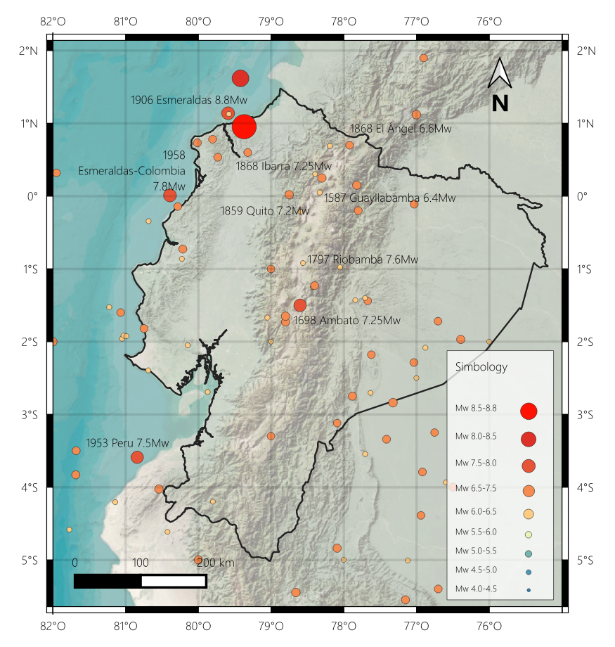
Some of the historical earthquakes in the Sierra region of Ecuador within a time window from 1587 to 1996 have been carefully studied in Beauval et al. (2010), these events are used in the final compiled catalog. Notable among them are the following earthquakes: the 1587 Guayllabamba 6.4Mw, 1698 Ambato 7.25Mw, 1797 Riobamba 7.6Mw, 1859 Quito 7.2Mw, 1868 Ibarra 7.25Mw, 1868 El Ángel 6.6Mw, 1958 Esmeraldas-Colombia 7.8Mw, among others.
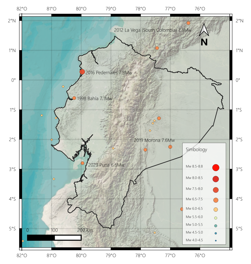
Events occurring after 1996 have also been included in the seismic catalog, including significant events that, while not occurring within the national territory, could impact buildings in Ecuador. These events include earthquakes such as the 1998 Bahía 7.1Mw, 2005 North Peru 7.5Mw, 2012 La Vega (South Colombia) 7.3Mw, 2016 Pedernales 7.8Mw, 2019 Morona 7.6Mw, 2023 Puna 6.6Mw, among others
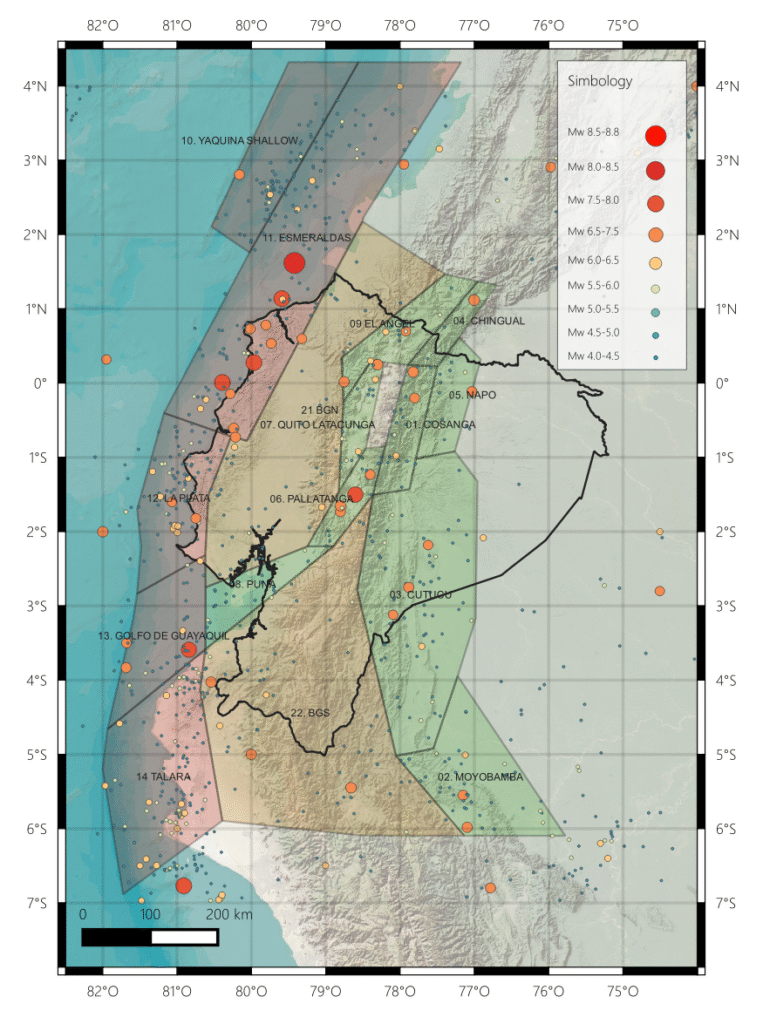
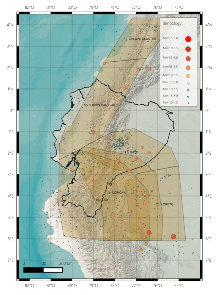
The seismogenic source areas employed in this research are those utilized in Beauval et al. (2018), these source zones are defined as volumes of the lithosphere that share similar seismic characteristics. The study of source zones has evolved over the years since the initial investigations by Yepes et al. (2016), where seismogenic sources were proposed to model earthquake occurrences on shallow crustal faults and at the subduction interface. This information allows for the assignment of earthquakes treated and homogenized in the catalog of this study, similarly, source zones are employed for the intraplate interface, and earthquakes associated with this mechanism are assigned accordingly.
To ensure full functionality, this interactive tool has been optimized for use on desktop computers. It may not display correctly on mobile devices. Please zoom in to locate the target city and click on the corresponding grid cell. You will then be able to access the Uniform Hazard Spectra (UHS) and seismic hazard curves for that location.
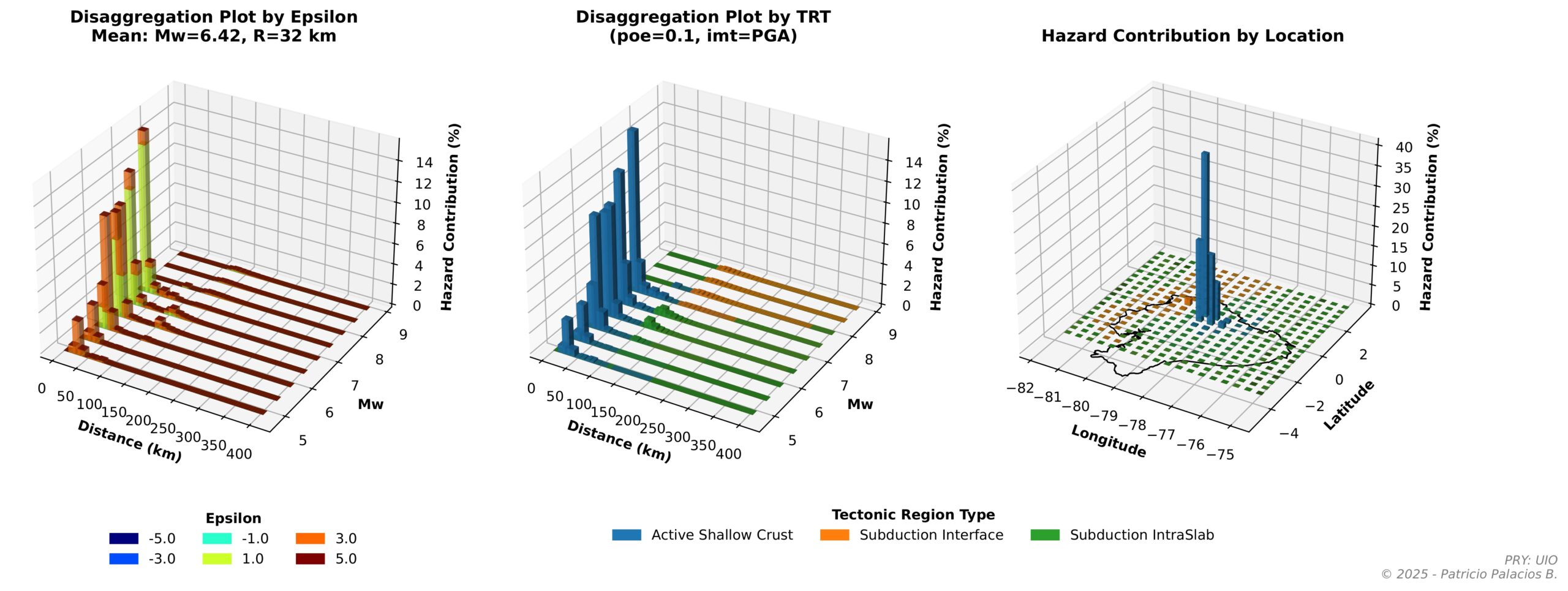
Seismic Desaggregation
Seismic disaggregation enables the interpretation of probabilistic seismic hazard analysis (PSHA) results by identifying the combinations of earthquake magnitude and source-to-site distance—along with associated focal mechanisms and rupture directions—that contribute most significantly to the seismic hazard level at a specific site and for a given structural response period.
Disclaimer for Seismic Hazard Research
This document is presented as a technical draft intended solely for seismic hazard research for academic purposes. The information contained in this report is subject to ongoing review and may be modified without prior notice. The authors of this document assume no responsibility for the interpretation, use, or misunderstanding of the information provided herein.
It should be noted that this report is based on data collected and methodologies established up to the date of its preparation. Consequently, any changes in the understanding of seismology, geological conditions, or seismic hazard assessment methodologies may affect the validity of the conclusions presented in this document.
Users of this report are responsible for verifying the currency of the information and for considering any additional scientific developments that may have occurred after the publication date. It is strongly recommended that any practical application of the information contained in this report be carried out by professionals trained in the fields of seismology and structural engineering.
This disclaimer is issued with the purpose of protecting the authors and does not absolve users of the responsibility to critically assess the information provided and to seek professional advice when necessary. The authors are not liable for any damage or loss that may arise from the use of this document for practical purposes or design decisions.